
Loading...
SKU:
NACH1028
Imray 2500 Channel Islands Chart Pack
£59.95
Unit price
/
Unavailable
Tax included
Shipping calculated at checkout.
Imray 2500 Channel Islands Chart Pack is backordered and will ship as soon as it is back in stock.
Couldn't load pickup availability
Imray 2500 Channel Islands Chart Pack
£59.95
Unit price
/
Unavailable
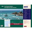
Imray 2500 Channel Islands Chart Pack | YOT0856 ISBN 9781846238611
Covering Alderney, Guernsey, Jersey and Cherbourg to St Malo in a folio of 17 handy A2 charts in a sturdy plastic wallet.
The chart pack includes all the navigational charts and tidal data for passage, approach and mooring.
Ideal for small craft.
Included
- 2500.1 Approaches to the Channel Islands
- 2500.2 Cap Barfleur to Alderney, including plans of Charbourg
- 2500.3 Alderney & Burhou, including plan of Alderney harbour
- 2500.4 Passages between Alderney & Guernsey including plan of Dielette
- 2500.5 Guernsey, Herm & Sark
- 2500.6 East Guernsey & Herm
- 2500.7 Guernsey & Sark plans - St Peter Port, Beaucette Marina, Sark Anchorages, Guernsey south coast anchorages
- 2500.8 Passages between Guernsey & Jersey, includes plan of Carteret
- 2500.9 Jersey & Les Ecrehou
- 2500.10 Approaches to St Helier, including St Helier Harbour plan
- 2500.11 East Coast of Jersey
- 2500.12 Jersey to Granville, including plan of Granville
- 2500.13 Plateau des Minquiers
- 2500.14 Plateau des Minquiers to St Malo, including St Malo plan
- 2500.15 Iles Chausey
- 2500.16 St Malo & La Rance, including continuation to Lyvet
- 2500.17 La Rance - Cancaval to Lyvet
