
Loading...
SKU:
NACH1038
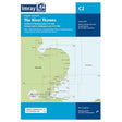
Imray Chart C2 The River Thames
£28.95
Unit price
/
Unavailable
Tax included
Shipping calculated at checkout.
Imray Chart C2 The River Thames is backordered and will ship as soon as it is back in stock.
Couldn't load pickup availability
Imray Chart C2 The River Thames
£28.95
Unit price
/
Unavailable
Imray Chart C2 The River Thames
Imray C2 - The River Thames, Teddington to Southend - Printed on Pretex waterproof paper and supplied folded to A4 size (Open size: 79x112cm), the award winning Imray C-Series charts make plotting easier whatever the conditions.
Features:
- WGS 84 datum
- Detailed cartography based on up-to-date official surveys
- Clear colour definition of shoal and drying areas with coloured light sectors
- Large-scale plans of harbours
- Tidal stream information based on the Admiralty pattern of `diamonds' as well as the usual tidal constants. Most charts include tidal stream diagrams
- Details of radio services
- Information on facilities for yachtsmen, where the scale of the chart is suitable, with telephone numbers
- Printed on the reverse is information concerning signs, symbols and abbreviations as well as useful general information about weather, tides and, where relevant, glossaries of foreign terms
