
Loading...
SKU:
NACH1051
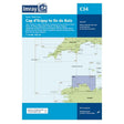
Imray Chart C34 Cap D'Erquy to Ile De Batz
£28.95
Unit price
/
Unavailable
Tax included
Shipping calculated at checkout.
Imray Chart C34 Cap D'Erquy to Ile De Batz is backordered and will ship as soon as it is back in stock.
Couldn't load pickup availability
Imray Chart C34 Cap D'Erquy to Ile De Batz
£28.95
Unit price
/
Unavailable
Imray Chart C34 Cap D'Erquy to Ile De Batz
This edition includes the latest official SHOM (French Hydrographic Office) data, combined with additional information sourced from Imray's network to make it ideal for small craft. The chart has been revised throughout.
Plans:
- Primel (1:15 000)
- Le Léguer (1:42 500)
- Trébeurden (1:25 000)
- Ploumanac'h (1:10 000)
- Anse de Perros (1:30 000)
- Perros-Guirec (1:15 000)
- Port-Blanc (1:25 000)
- Approaches to Riviére de Tréguier (1:45 000)
- Tréguier (1:15 000)
- Approaches to Riviére de Trieux and Paimpol (1:50 000)
- Port de la Corderie (Ile de Bréhat) (1:15 000)
- Port Clos (Ile de Bréhat) (1:10 000)
- Lézardrieux (1:15 000)
- Paimpol (1:15 000)
